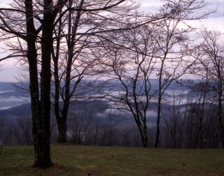
I've spent a lot of time trying to understand where Droop Mountain fits in the geology and biogeography of the Appalachians. Maurice Brooks' The Appalachians (1965) seems to place it either in the Allegheny Mountains or immediately west of it. Despite the hours I've spent with topo maps, I can't quite understand if Droop is in the Yew Pine Mountains, or between them and the Alleghenies. Despite finding Droop interesting enough to mention, Brooks never quite spells it out.
Brooks mentions an unnamed muskeg (a bog, like the Cranberry Glades) somewhere on Droop.
Mrs. Graham Netting found an orchid rarity, Small's twayblade (Listeria smallii), not known elsewhere in Cranberry but common in a rich (and unnamed muskeg on Droop Mountain, about twenty miles away. There are other plant specialties in these southern muskegs. The one on Droop Mountain, just mentioned, has thousands of plants of netted chain-fern (Woodwardia areolata), a species associated with coastal plains, seemingly out of place on a 3000-foot mountain....
Brooks' The Appalachians includes a very helpful breakdown of western Virginia and West Virginia in this passage:
The westward escarpment that defines the Shenandoah Valley is called North Mountain, and with it we may again take up the course of Paleozoic geology. Old Appalachia is to the east; the Great Valley and the ridges beyond are a part of New Appalachia, where rocks are sedimentary, and where the fossil record of ancient life has been preserved. In parts of the valley, and just westward, there are outcrops that date from the...Cambrian....
North Mountain (with its counterparts north and south) marks the beginning of a distinctive Appalachian topographic province, the Ridge and Valley Province. Comparatively low but steeply abrupt ridges are arranged parallel to each other on a northeast-southwest axis. Between these ridges are streams, tributaries of the Potomac River, which form a trellised drainage pattern....
Just over a hundred miles west from Washington, the Alleghenies rise abruptly one or two thousand feet above the Ridge and Valley Province. This escarpment marks the beginning of a new topographic province. On its higher expanses it recaptures much of the northern atmosphere that occurs on Blue Ridge summits, and it introduces many new plants and animals of boreal distribution. To add further to its biological significance, it shelters surprising numbers of plant and animal endemics. Greatest elevations normally occur along the axis ridge known as Allegheny Backbone, but there are also extensive areas above 4000 feet on such westward ridges as Cheat, Gauley, and Back Allegheny.
Along higher Allegheny crests there is a southward extension of the red spruce forest, so typical of Maine and New Brunswick. Here hermit and Swainson's thrushes nest, red crossbills occur at all seasons, and varying hares, brown in summer and white in winter, reach their farthest southward limits. Visitors will soon come to recognize the loosely cemented sand and coarse gravel, geologically Pottsville conglomerate, which outcrops on many of the higher Allegheny peaks. Another characteristic Mississippian formation is Greenbrier limestone, holding within its depths many of the caves which we shall be discussing in a later chapter. Some of Appalachia's finest ferns are at home on these limestone ledges.
Between high Allegheny ridges and the prairies of interior America is a region of eroded hills, which are dissected by streams that flow in almost every possible direction and then are finally drawn to the Ohio River. So broken and irregular is the topography that it takes close looking to see this area as a plateau, but actually the hilltops maintain remarkably even elevations. This is the Appalachian Plateau, with outcrops that date from the Pennsylvanian Period to the east and from the Permian to the west, where hills run out and the level lands begin.
Within Pennsylvanian formations are some of the richest coal beds the world holds. The Pittsburgh coal seam has often been called, and with justification, "the world's most valuable mineral deposit." This and other coal seams have profoundly affected the habitance and economy of the region, since the mining of coal is ever an ugly and destructive process. Still, there are forests in the coves, remarkably rich and varied ones, with trees that suggest regions farther north or farther south.
pages 13-17
No comments:
Post a Comment